CENTRE WELLINGTON – As Centre Wellington moves closer to finalizing an expanded urban boundary for Elora and Fergus, developers lined up one-by-one Tuesday to make their case as to why land they own should be included.
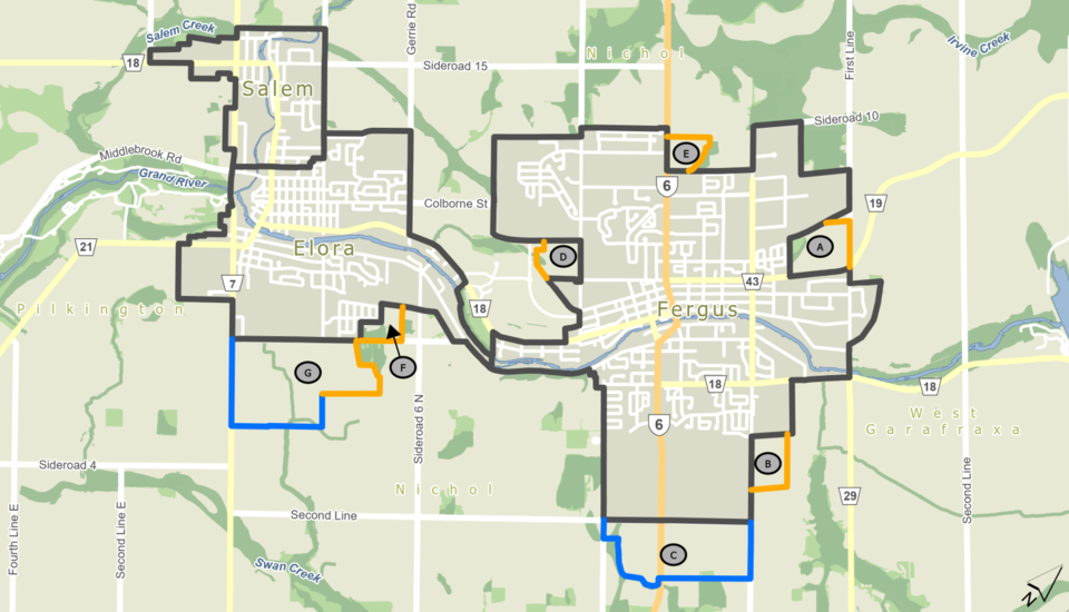
A report by Brett Salmon, Centre Wellington’s managing director of planning and development, laid out seven different parcels recommended to be added to the urban areas of Elora and Fergus, called settlement area boundary expansion (SABE) lands.
Lands within settlement areas are not guaranteed to be approved for housing, commercial or industrial use, but this designation clears a hurdle for developers looking to build as planning policies give a strong preference to those looking to build within urban boundaries.
The SABE lands staff proposed to be added are five areas in Fergus on all sides of the town and two areas of Elora at the south end of the village. It represents about 43 hectares of community land in Elora, 89 hectares of community land in Fergus and a total of 194 hectares of employment land in both for a total of 326 hectares or 805 acres.
It is less land than was previously identified as needed to accommodate expected population and job growth handed down from the County of Wellington, but council endorsed a scenario which increased the intensification rate from 40 people and jobs per hectare to 53 people and jobs per hectare.
Salmon noted in the report all SABE lands are adjacent to municipal sewer and water services or would be available when other land is built, most is surrounded by existing development, near active transportation routes and future employment lands are near Wellington Road 7 and Highway 6.
In staff’s pursuit to follow council’s intensification direction, many land owners were left out of the equation and about a dozen showed up, presented or wrote to council to explain why they should reconsider not including their land.
Many argued their lands were well suited for development as they represented logical rounding out of urban boundaries, were not active farmland any longer, avoided fracturing farmland parcels and could provide needed housing.
These landowners, developers and their representatives included:
- John Xintavelonis, land owner at 456 Wellington Rd. 7 north of Elora
- Tom Keating of James Keating Construction, owner of a farm property north of Elora
- Robin McIntyre, MHBC Planning on behalf of Skyway Estates Ltd., owner of a parcel at 6686 Irvine St. north of Salem
- Michael Puopolo, Polocorp CEO, who had some of their land off Highway 6 in north Fergus included but wanted more to be considered
- Juliane von Westerholt, MHBC on behalf of Elora Greens Inc. asked for the rest of a farmland parcel in south Elora to be included
- Marlene and Ted Buczek at 6585 Highway 6 just north of Fergus looking to bring in not-for-profit housing developer Home Opportunities to build affordable housing at their farm
- Tribute Limited asked for its land off Beatty Line in Fergus near its Storybrook subdivision to be added in a letter
- Emily Elliott, MHBC on behalf of Biltmore Homes said including 745 Anderson St. in east Fergus would be good use of unused farmland
- Breymark Homes representatives said their north Fergus land would be land locked by Polocorp’s land and the township’s new operations centre, meaning it could be included with Polocorp’s land to create a complete community
- Samantha Boehmer of Elora asked for her small farm, not actively used for agriculture, near the South River subdivision to be included as it was right on the edge of where the boundary is.
Keating noted he was asked by the CAO in an email to respect the process and not reach out to staff but wanted an opportunity to sit down to better understand the rationale behind why some properties weren’t included.
“There’s a lot of people at the table that have land and there’s just not enough need to bring in that number of properties,” Keating said. “When I review the map, I’ve seen a priority to grow to the south rather than growing our two towns together. So then is this the future of growth for our municipality or is that the direction of growth for this expansion?”
Later in the meeting when Salmon was presenting his report he noted although it would be impossible not to expand into any farmland through this process, staff were directed to minimize the amount needed to be encroached on.
If council wished to add land based on what they’ve heard, Salmon said that would mean removing land elsewhere or approving more than is needed at this time.
“Those requests we’ve heard just this evening add up to more land than we’ve added in our proposed boundary,” Salmon said. “If council wishes to stick to its objective of minimizing the amount of farmland (added to the urban boundary), we’ve identified exactly that amount of land.”
Council accepted the report for information and a recommendation is expected to come forward at a later council meeting.